Settings - GeoCoordination Services
From the backstage, clicking on Settings and then selecting the GeoCoordination Services section changes the following parameters.
|
Download path |
This is the folder in which the contextual data will be downloaded when accessing the GeoCoordination Services. |
GeoCoordination Services Data Classes
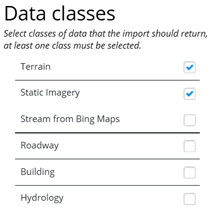
From the backstage clicking on GeoCoordination Services displays the GeoCoordination Services dialog containing this class option menu.
Select one of the options, Static Imagery or Stream from Bing Maps, or deselect both but cannot select both at the same time.